


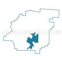
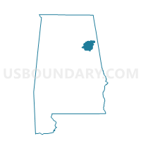
Anniston, Calhoun County, Alabama
About
Outline

Summary
| Unique Area Identifier | 521311 |
| Name | Anniston |
| County | Calhoun County |
| State | Alabama |
| Area (square miles) | 35.23 |
| Land Area (square miles) | 35.17 |
| Water Area (square miles) | 0.05 |
| % of Land Area | 99.85 |
| % of Water Area | 0.15 |
| Latitude of the Internal Point | 33.67914960 |
| Longtitude of the Internal Point | -85.81854840 |
Maps

Graphs
Select a template below for downloading or customizing gragh for Anniston, Calhoun County, Alabama


Neighbors
Neighoring Voting District (by Name) Neighboring Voting District on the Map
- 1st Presby/Mental Health/Golden Springs/Donoho Voting District, Calhoun County, AL
- Eulaton/Bynum/West Park Heights Bapt. Voting District, Calhoun County, AL
- Four Mile Methodist Church, Calhoun County, AL
- Oxford Lake Park/Cheaha Club Voting District, Calhoun County, AL
- Saks High/ Leatherwood Civil Defence Voting District, Calhoun County, AL
- Weaver First United Methodist/Angel Fire Dept. Voting District, Calhoun County, AL
Top 10 Neighboring County Subdivision (by Population) Neighboring County Subdivision on the Map
Top 10 Neighboring Place (by Population) Neighboring Place on the Map
- Anniston city, AL (23,106)
- Oxford city, AL (21,348)
- Saks CDP, AL (10,744)
- West End-Cobb Town CDP, AL (3,465)
- Weaver city, AL (3,038)
- Hobson City town, AL (771)
Top 10 Neighboring Unified School District (by Population) Neighboring Unified School District on the Map
- Calhoun County School District, AL (57,392)
- Oxford City School District, AL (23,361)
- Anniston City School District, AL (23,106)
Top 10 Neighboring State Legislative District Lower Chamber (by Population) Neighboring State Legislative District Lower Chamber on the Map
- State House District 40, AL (49,653)
- State House District 36, AL (46,065)
- State House District 35, AL (44,612)
- State House District 32, AL (38,800)
Top 10 Neighboring State Legislative District Upper Chamber (by Population) Neighboring State Legislative District Upper Chamber on the Map
Top 10 Neighboring 111th Congressional District (by Population) Neighboring 111th Congressional District on the Map
Top 10 Neighboring Census Tract (by Population) Neighboring Census Tract on the Map
- Census Tract 18, Calhoun County, AL (6,919)
- Census Tract 11, Calhoun County, AL (6,565)
- Census Tract 17, Calhoun County, AL (6,329)
- Census Tract 10, Calhoun County, AL (5,792)
- Census Tract 12.02, Calhoun County, AL (4,318)
- Census Tract 16, Calhoun County, AL (3,791)
- Census Tract 14, Calhoun County, AL (3,731)
- Census Tract 12.01, Calhoun County, AL (3,482)
- Census Tract 9, Calhoun County, AL (3,362)
- Census Tract 2, Calhoun County, AL (3,104)
Top 10 Neighboring 5-Digit ZIP Code Tabulation Area (by Population) Neighboring 5-Digit ZIP Code Tabulation Area on the Map
- 36201, AL (20,156)
- 36207, AL (19,801)
- 36203, AL (18,799)
- 36206, AL (11,427)
- 36277, AL (5,420)
- 36205, AL (635)